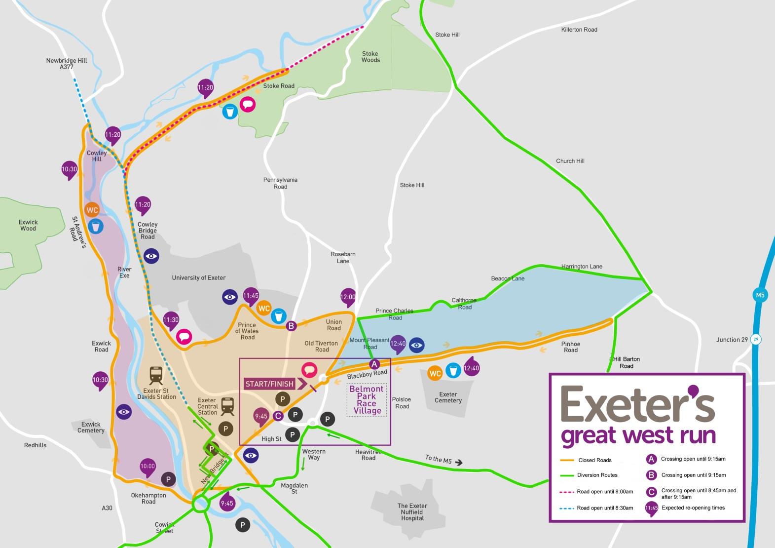


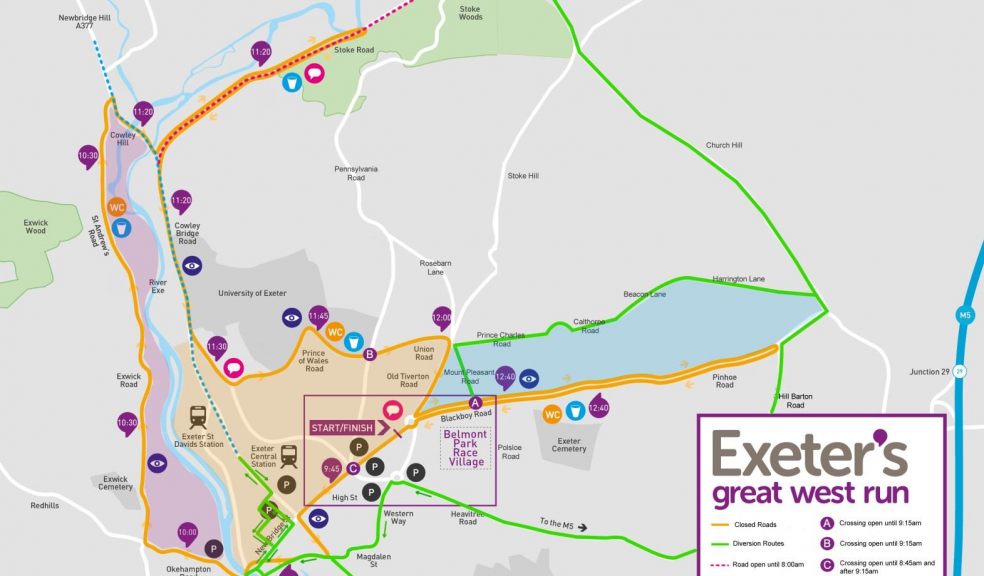
Great West Run route and road closures
Exeter’s Great West Run will be taking place on Sunday 18th October 2015.
This established half marathon is an annual fixture in the city’s calendar, and expects to attract around 4,000 runners, many of whom are fundraising for local and national charities.
Using the city’s streets for the race will cause changes to usual traffic routes for a limited period on Sunday 18th October.
In planning the event every effort is made to minimise the disruption caused with the closing of roads.
Where closures occur, and where possible, diversions will be in place to ensure continued access around the city for motorists and public transport. To aid the flow of traffic prior to the race start, a number of crossing points will be in operation (see attached map).
Roads to be closed, or partially closed, on Sunday 18th October 2015
• Belmont Road (PARKING RESTRICTIONS IN PLACE)
• Clifton Hill
• Western Way (B3212- Blackboy Road to Heavitree Road only)
• Summerland Street (PARKING RESTRICTIONS IN PLACE)
• Sidwell Street (PARKING RESTRICTIONS IN PLACE)
• High Street
• South Street
• Western Way (A3015- Eastbound only)
• Frog Street
• A377/Exe Bridges (one northbound lane)
• Okehampton Street
• Okehampton Road
• Exwick Road
• St Andrews Road
• Crediton Road
• Stoke Road
• Cowley Bridge Road
• New North Road
• Streatham Drive
• Prince of Wales Road
• Union Road
• Pennsylvania Road (junction with Prince of Wales Road and Union Road)
• Old Tiverton Road
• Pinhoe Road
• Blackboy Road
Road closures will be in operation from 6.00am in most areas and will re-open once runners have passed by, and it is safe to do so. Roads will begin to re-open from 9.30am with all being re-opened fully by 1.00pm (with the exception of Summerland Street, Western Way, Belmont Road and Clifton Hill which will re-open by 2.00pm and Sidwell Street which will re-open by 4.00pm).
A map of the 2015 route is attached. Please refer to the information below for specific access information in the coloured areas and contact us with any unanswered queries. Please note that estimated re-opening times are detailed.
Pink Area: Exwick Road and St Andrews Road will be closed between 6.00am and 10.30am, should you need to leave your property during this time period, please consider moving your vehicle to the west of Exwick Road on Saturday evening. You can then exit using Redhills and Buddle Lane.
Orange Area: For egress please use Exe Bridges - from the Clock Tower on New North Road, use Queen Street, Paul Street, Bartholomew Street and New Bridge Street to exit the city at Exe Bridges (see green on attached).
Blue Area: For egress please use the following diversion to the east of the city - the diversion route runs from Mount Pleasant Road, via Prince of Charles Road, Calthorpe Road, Beacon lane, Harrington Lane and down onto Hill Barton Lane. Alternatively and where possible please consider parking south of Pinhoe Road on Saturday evening.
Jamie Warren, Head of Marketing and Commercial at GO2, said: “We have carefully considered the race route and all appropriate diversions, along with key open roads and access points. We appreciate your understanding with any inconvenience you experience due to these restrictions, and hope this advance notice helps with planning your travel around the closures. Please do allow extra time for your journey, and consider parking your vehicle on a nearby alternative street on the evening of Saturday 17th October, to enable you to carry out your journey on Sunday morning.”
If you require any further information, or a detailed list of the diversions that will be in place, please email the organiser at info@go2events.org.uk or call on 0845 4812 149.